Water Spouts will speak volubly and endlessly about all the issues concerning water. The ongoing degradation, and growing scarcity, of the water supply here in the US, and the rest of the world. The continued absence of potable water in so many parts of the world. The work being done by NGOs, and charities, in the third world, to help alleviate the situation. The emphasis on WASH ( Water, Sanitation, and Hygiene ) so health and healthy water are maintained. "Water Spouts" will spout it all out.
One indicator that climate change will
impact not just future generations, but people living today, is the
Arctic’s stunning pace of ice melt. Scientists are now predicting that
the vast polar region at the top of the world could be ice-free during
the summer as early as 2030.
Such a change has many consequences.
Increased Human Activity:
With shipping routes unencumbered by ice, human activity will increase
in the region. Despite the concerns of many environmental groups, Shell
has sent deepwater drilling exploration vessels to the Arctic in
anticipation of establishing oil and gas operations there. This resource
rush also has security implications as countries bordering the region have increased their military presence there.
Wildlife: According to the National Wildlife Federation,
the Arctic is home to a complex and productive ecosystem that depends
on summer ice cover. Arctic foxes, caribou, whales and the iconic (and
endangered) polar bear are all under threat from the region’s
accelerated pace of warming and increased human activity. The native
populations that depend on these ecosystems to preserve traditional ways
of life are already being impacted.
Accelerated Global Warming Impacts:
In 2007, scientists from the Intergovernmental Panel on Climate Change
(IPCC) anticipated that Arctic summer ice would disappear by 2100 if
greenhouse gas levels remained unchecked, but subsequent years of
observation have shown that ice is melting more rapidly that anyone
projected. This kind of miscalculation shows how unpredictable climate
change can be. Some of the expected impacts of Arctic ice loss include colder and more extreme Northern Hemisphere winters, and accelerated global warming from the release of methane and the loss of reflective surfaces.
The best way to reign in the dramatic changes happening in the Arctic is to limit the greenhouse gas emissions that are causing global warming.
Many EarthShare member organizations are working on just that while
also communicating the reasons why the Arctic is such an important
barometer for the future of our planet.
As Shell’s rigs head toward the Arctic to exploit melting sea ice to
drill for more oil, the company took a small step this weekend in
clarifying what would happen in an oil spill during the company’s
planned Arctic drilling operations this summer.
Despite the oil industry’s spin, experts know it is impossible to
recover more than a small fraction of a major marine oil spill, as
retired Coast Guard Admiral Roger Rufe told NPR:
“But once oil is in the water, it’s a mess. And we’ve never proven
anywhere in the world — let alone in the ice — that we’re very good at
picking up more than 3 or 5 or 10 percent of the oil once it’s in the
water.”
So how is it possible, according to the New York Times,
that Interior Secretary Ken Salazar “said he believed the company’s
claims that it could collect at least 90 percent of any oil spilled in
the event of a well blowout.” These sorts of claims have raised eyebrows
among advocates and scientists who study offshore oil drilling — they
aren’t just unbelievable, they’re laughably, outrageously impossible. NPR’s Richard Harris cuts through Shell’s spin, and explains what these numbers really mean:
“They have a miniscule number of boats compared to what
was available in the Gulf of Mexico,” [Peter Van Tuyn, and environmental
lawyer in Anchorage] says, and in the Gulf, “they didn’t have to deal
with the extreme weather conditions that we’ve got in the Arctic.” High
winds are the norm, and sea ice is always a possible hazard, “and yet
they [Shell] claim they can collect as much as 95 percent.”
Merrell says the company has made no such claim. Instead, he says, the oil company’s plan is to confront 95 percent of the oil out in the open water, before it comes ashore. That doesn’t mean responders can collect what they encounter.
“Because the on-scene conditions can be so variable, it would be rather ridiculous of us to make any kind of performance guarantee,” Merrell says.
While discussing the same issue with the Associated Press, Shell PR folks take another word out for a spin, and even try to blame “opposition groups” for this confusion:
Shell Alaska spokesman Curtis Smith said opposition
groups are purposely mischaracterizing Shell’s oil spill response plan.
The plan does not claim Shell can clean up 90 percent of an oil spill,
he said.
“We say in our plan we expect to ‘encounter’ 90 percent
of any discharge on site — very close to the drilling rig,” he said.
“We expect to encounter 5 percent near-shore between the drilling rig
and the coast. And we expect to encounter another 5 percent on shore. We never make claims about the percent we could actually recover, because conditions vary, of course.”
Where Shell plans to drill in the Arctic, those conditions include 20
foot swells, hurricane force winds, sea ice, and months of total
darkness, and all without deep water ports or other infrastructure
needed to mount a major oil spill response. But let’s put that aside for
a moment, to make sure we’re not mischaracterizing here: Shell expects
to “encounter” or “confront” 90% of the spilled oil and another 5% the
company plans to — rendezvous? — with elsewhere in the ocean, while the
remaining 5% Shell might — happen upon? — on shore. How much of that oil
might be recovered, collected, or, you know, removed from the
environment? Well, Shell says conditions vary, so making a performance
guarantee would be rather ridiculous.
In the relatively calm conditions of the Gulf of Mexico, with
thousands of response vessels, only a small fraction was recovered from
the BP oil disaster. Despite shameful efforts to spin its announcement, a
government report found that 4% of the oil was skimmed, and another 6% was burned. And as oil spill expert Rick Steiner observes,
even those estimates might be too high, and burning oil isn’t really
removing it from the environment: “It either went into the air as
atmospheric emissions, and some of that is pretty toxic stuff, or
there’s a residue from burning crude that sinks to the ocean floor,
sometimes in big thick mats.”
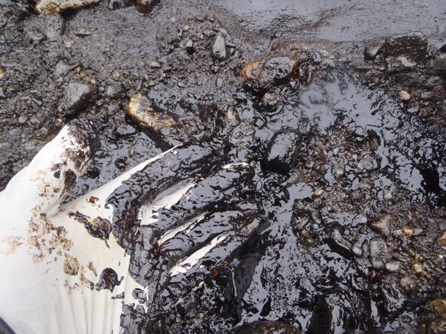
Exxon Valdez oil in 2012. Photo courtesy of David Janka, taken on May 24, 2012 on Eleanor Island, Prince William Sound, Alaska.
And today, 23 years later, most of the fish and wildlife
populations and habitats injured by the spill have yet to fully recover,
and there is still residual, toxic oil in beach sediments. It is
becoming evident that the injured Alaska coastal ecosystem may never
fully recover from the Exxon Valdez spill.”
What of the promised “state-of-the-art spill response”?
Despite a three-year, $2 billion effort by Exxon, the response was a
spectacular failure, recovering less than 7 percent of the spilled oil.
Oil that Exxon might have “encountered” decades ago, still remains
today, as do the impacts to the ecosystem and the wildlife and
communities that depend upon it.
12 August 2005, 8 PM local time, Photo from a helicopter flying over the
ice sheet surface at ~1500 feet altitude. This is how much darker the
Greenland ablation area is than a fresh snow surface that blankets it in
wintertime. Along much of the southwestern ice sheet at the lowest 1000
m in elevation, impurities concentrate near the surface and produce
this dark surface. Not all of the ice sheet is this dark, only the lower
~1/3 of the elevation profile of the ice sheet is. However, as melting
increases on the ice sheet, so does the area exposed that is this dark.
Freshly fallen snow under clear skies reflects 84% (albedo= 0.84) of
the sunlight falling on it (Konzelmann and Ohmura, 1995). This
reflectivity progressively reduces during the sunlit (warm) season as a
consequence of ice grain growth, resulting in a self-amplifying albedo
decrease, a positive feedback. Another amplifier; the complete melting
of the winter snow accumulation on glaciers, sea ice, and the low
elevations of ice sheets exposes darker underlying solid ice. The albedo
of low-impurity snow-free glacier ice is in the range of 30% to 60%
(Cuffey and Paterson, 2010). Where wind-blown-in and microbiological
impurities accumulate near the glacier ice surface (Bøggild et al.
2010), the ice sheet albedo may be extremely low (20%) (Cuffey and
Paterson, 2010). Thus, summer albedo variability exceeds 50% over parts
of the ice sheet where a snow layer ablates by mid-summer, exposing an
impurity-rich ice surface (Wientjes and Oerlemans, 2010), resulting in
absorbed sunlight being the largest source of energy for melting during
summer and explaining most of the inter-annual variability in melt
totals (van den Broeke et al. 2008, 2011).
The photo below shows how dark the ice sheet surface can become in
the lowest ~1000 m elevation in the “ablation area” after the winter
snow melts away and leaves behind an impurity-rich surface. This dark
area is where the albedo feedback with melting is strongest.
Satellite observations from the NASA Moderate-Resolution Imaging
Spectroradiometer (MODIS) indicate a significant Greenland ice sheet
albedo decline (-5.6±0.7%) in the June-August period over the 12 melt
seasons spanning 2000-2011. According to linear regression, the ablation
area albedo declined from 71.5% in 2000 to 63.2% in 2011 (time
correlation = -0.805, 1-p=0.999). The change (-8.3%) is more than two
times the absolute albedo RMS error (3.1%). Over the accumulation area,
the highly linear (time correlation = -0.927, 1-p>0.999) decline from
81.7% to 76.6% over the same period also exceeds the absolute albedo
RMS error.
Greenland ice sheet average reflectivity or albedo (multiply by 100 to get % units) for 12 summer (June-August) periods.
According to Jason Box, the lead author of the Greenland chapter of
the 2011 Arctic Report Card and the analyst of the reflectiveness data,
the darkening in the interior is just as remarkable than the changes at
the margins. The interior is the high-point of the dome-shaped ice
sheet, rising to nearly two miles above sea level. There is no visible
melting there in the summer, so why is the area becoming darker?
Map of changes in the percent of light reflected by the Greenland Ice
Sheet in summer (June-July-August) 2011 compared to the average from
2000-2006. Virtually the entire surface has grown darker due to surface
melting, dust and soot on the surface, and temperature-driven changes in
the size and shape of snow grains. Map by NOAA’s climate.gov team,
based on NASA satellite data processed by Jason Box, Byrd Polar Research
Center, the Ohio State University.
The darkening in the non-melting areas, says Dr. Box, is due to changes
in the shape and size of the ice crystals in the snowpack as its
temperature rises. Snow grains clump together, and they reflect less
light than the many-faceted, smaller crystals. Additional heat rounds
the sharp edges of the crystals. Round particles absorb more sunlight
than jagged ones do.
A freshly fallen snow crystal has numerous facets to reflect sunlight
(left). Warming causes the grains to round at the edges and clump
together (right). Scanning electron microscope photos courtesy the
Electron and Confocal Microscopy Laboratory, USDA Agricultural Research
Service.
On the Kangerdlugssuaq Glacier -- one of Greenland's largest ice fields
-- scientists measure the movement of the ice sheet as it transports
frozen water to the ocean. They discover that the speed of the glacier's
march to the sea has tripled in just ten years. Alarm bells sound
because at the current melt rate, within a few decades rising seas will
have a profound effect on the low-lying countries of the world.
Once
considered an inexhaustible source of food, the oceans are now in
danger of being significantly depleted. Matt Damon hosts "The State of
the Planet's Oceans" as award-winning filmmakers Hal and Marilyn Weiner
investigate the health and sustainability of the world's oceans and the
issues affecting marine preserves, fisheries, and coastal ecosystems
worldwide.
Keys to climate change lie buried beneath "Lake E" in the Russian Arctic. (Credit: Pavel Minyuk)
Intense warm climate intervals--warmer than scientists thought
possible--have occurred in the Arctic over the past 2.8 million years.
That result comes from the first analyses of the longest sediment
cores ever retrieved on land. They were obtained from beneath remote,
ice-covered Lake El'gygytgyn (pronounced El'gee-git-gin) ("Lake E") in
the northeastern Russian Arctic.
The journal Science published the findings this week.
They show that the extreme warm periods in the Arctic correspond
closely with times when parts of Antarctica were also ice-free and warm,
suggesting a strong connection between Northern and Southern Hemisphere
climate.
The polar regions are much more vulnerable to climate change than
researchers thought, say the National Science Foundation-(NSF) funded
Lake E project's co-chief scientists: Martin Melles of the University of
Cologne, Germany; Julie Brigham-Grette of the University of
Massachusetts Amherst; and Pavel Minyuk of Russia's North-East
Interdisciplinary Scientific Research Institute in Magadan.
The exceptional climate warming in the Arctic, and the
inter-hemispheric interdependencies, weren't known before the Lake E
studies, the scientists say.
Lake E was formed 3.6 million years ago when a huge meteorite hit
Earth, leaving an 11-mile-wide crater. It's been collecting layers of
sediment ever since.
The lake is of interest to scientists because it has never been
covered by glaciers. That has allowed the uninterrupted build-up of
sediment at the bottom of the lake, recording hitherto undiscovered
information on climate change.
Cores from Lake E go far back in time, almost 30 times farther than Greenland ice cores covering the past 110,000 years.
The sediment cores from Lake El'gygytgyn reflect the climate and
environmental history of the Arctic with great sensitivity, say
Brigham-Grette and colleagues.
The physical, chemical and biological properties of Lake E's
sediments match the known global glacial/interglacial pattern of the ice
ages.
Some warm phases are exceptional, however, marked by extraordinarily
high biological activity in the lake, well above that of "regular"
climate cycles.
To quantify the climate differences, the scientists studied four warm
phases in detail: the two youngest, called "normal" interglacials, from
12,000 years and 125,000 years ago; and two older phases, called
"super" interglacials, from 400,000 and 1.1 million years ago.
According to climate reconstructions based on pollen found in
sediment cores, summer temperatures and annual precipitation during the
super interglacials were about 4 to 5 degrees C warmer, and about 12
inches wetter, than during normal interglacials.
The super interglacial climates suggest that it's nearly impossible
for Greenland's ice sheet to have existed in its present form at those
times.
Simulations using a state-of-the-art climate model show that the high
temperature and precipitation during the super interglacials can't be
explained by Earth's orbital parameters or variations in atmospheric
greenhouse gases alone, which geologists usually see as driving the
glacial/interglacial pattern during ice ages.
That suggests that additional climate feedbacks are at work.
"Improving climate models means that they will better match the data
that has been collected," says Paul Filmer, program director in NSF's
Division of Earth Sciences, which funded the "Lake E" project along with
NSF's Office of Polar Programs.
"The results of this collaboration among scientists in the U.S.,
Austria, Germany and Russia are providing a challenge for researchers
working on climate models: they now need to match results from
Antarctica, Greenland--and Lake El'gygytgyn."
Adds Simon Stephenson, director of the Division of Arctic Sciences in
NSF's Office of Polar Programs, "This is a significant result from
NSF's investment in frontier research during the recent International
Polar Year.
"'Lake E' has been a successful partnership in very challenging
conditions. These results make a significant contribution to our
understanding of how Earth's climate system works, and improve our
understanding of what future climate might be like."
The scientists suspect the trigger for intense interglacials might lie in Antarctica.
Earlier work by the international ANDRILL program discovered
recurring intervals when the West Antarctic Ice Sheet melted. (ANDRILL,
or the ANtarctic geological DRILLing project, is a collaboration of
scientists from five nations--Germany, Italy, New Zealand, the United
Kingdom and the United States--to recover geologic records from the
Antarctic margin.)
The current Lake E study shows that some of these events match with the super interglacials in the Arctic.
The results are of global significance, they believe, demonstrating
strong indications of an ongoing collapse of ice shelves around the
Antarctic Peninsula and at the margins of the West Antarctica Ice
Sheet--and a potential acceleration in the near future.
The Science paper co-authors discuss two scenarios for
future testing that could explain the Northern Hemisphere-Southern
Hemisphere climate coupling.
First, they say, reduced glacial ice cover and loss of ice shelves in
Antarctica could have limited formation of cold bottom water masses
that flow into the North Pacific Ocean and upwell to the surface,
resulting in warmer surface waters, higher temperatures and increased
precipitation on land.
Alternatively, disintegration of the West Antarctic Ice Sheet may
have led to significant global sea level rise and allowed more warm
surface water to reach the Arctic Ocean through the Bering Strait.
Lake E's past, say the researchers, could be the key to our global climate future.
The El'gygytgyn Drilling Project also was funded by the International
Continental Scientific Drilling Program (ICDP), the German Federal
Ministry for Education and Research, Alfred Wegener Institute,
GeoForschungsZentrum-Potsdam, the Russian Academy of Sciences Far East
Branch, the Russian Foundation for Basic Research, and the Austrian
Ministry for Science and Research.
In the long run the unfrozen north could cause devastation. But,
paradoxically, in the meantime no Arctic species will profit from it as
much as the one causing it: humans. Disappearing sea ice may spell the
end of the last Eskimo cultures, but hardly anyone lives in an igloo
these days anyway. And the great melt is going to make a lot of people
rich. – The Economist
Official military doctrine in the United States now holds that
“climate change, energy security, and economic stability are
inextricably linked.” Nowhere is this linkage more clearly illustrated
than in the Arctic, and that’s why we think the region is a bellwether
for how climate change may reshape global geopolitics in the post-Cold
War era.
New and expanded shipping routes through the Arctic can cut the
distance to transport goods between Asia, North America, and Europe by
up to 4000 miles. We’re seeing increased interest and investment in oil
and gas exploration. The United States Geological Survey (USGS)
estimates that 30 percent of the world’s undiscovered gas and 13 percent
of undiscovered oil lies in the Arctic. Russia likely possesses the
largest share of any country. There’s also growing interest in tourism
and fishing.
As the economic potential of the Arctic becomes more apparent,
governments and militaries have begun to reposition themselves. What’s
happening in the Arctic is the starkest example yet of the way climate
change directly affects international security.
Here are the main findings of our analysis:
Since 2008, Canada, Denmark, Norway, Russia, the United States,
the European Union, the Nordic countries and NATO have all made major
Arctic policy announcements. So many policy announcements from major
players in such a short time frame is highly unusual—not just for the
Arctic but for international affairs in general.
A prevalent theme in nearly all the policy announcements was the
need to protect the region’s environment in the face of rapid climate
change and increased economic activity.
In most statements, the states have emphasized their commitment
to cooperation and to the principles of international law. As one
example, the five coastal Arctic states—Canada, Denmark, Norway, Russia
and the United States—agreed in the 2008 Ilulissat Declaration to settle
any territorial disputes in the Arctic under the principles of the law
of the sea. On the other hand, many of the Arctic states’ actions and
statements make it clear that they intend to develop the military
capacity to act unilaterally, if necessary, to protect their national
interests in the region.
Most of the Arctic states are modernizing their military forces
in the Arctic. For example, the United States recently began operating
its newest class of fast attack submarines in the Arctic and the
Russians have begun building a new fleet of nuclear-powered submarines
for both fast attack and ballistic missile launching missions. Norway
announced plans to purchase 48 F-35 Joint Strike Fighters, and both
Norway and Denmark have equipped their navies with Arctic combat
capabilities. With countries rebuilding their Arctic military
capabilities. If political cooperation in the region should sour, most
will have forces that are prepared to compete in a hostile environment.
Non-Arctic states and organizations have also begun to consider
Arctic security as well. Of special relevance, NATO has begun to
coordinate with its Arctic members on search and rescue. Since Russia
views NATO with suspicion, the alliance’s role in the Arctic has the
potential to create tensions.
The principal cause of renewed national interest in the Arctic
is the increasing accessibility of Arctic waters. However, interests in
the region vary somewhat from country to country. As new sea routes open
up, Canada and Russia see their core interests as maintaining
sovereignty in their territorial waters, while the United States puts
greater emphasis on freedom of the seas for navigation. Russia,
meanwhile, has invested tens of billions of dollars in Arctic oil
projects, and its recent statements and actions suggest that it will act
to safeguard its oil wealth in the region. The importance of Arctic oil
will grow for all nations as oil prices continue to rise and the desire
for energy security grows.
Although all of the Arctic states emphasize the need for
cooperation, most have begun to rebuild their military capabilities
beyond a mere policing capacity. At the same time, existing multilateral
institutions are too weak to ensure that collegiality will prevail
should disagreements become entrenched. Based on our findings, our
principal recommendation is that the Arctic states move quickly to
strengthen existing multilateral mechanisms before resource competition
and core national interests take center stage.
A flouting mountain of grey and white ice, castellated and crevassed
like an Alpine ridge, the iceberg is vast: the size of two aircraft
carriers, maybe more. Scale is hard to judge in the Arctic because of
its ubiquitous icy-white backdrops.
Yet much the biggest part of the iceberg—perhaps nine times the size
of the visible part—is submerged and invisible. As it drags along the
bottom of the Jakobshavn Fjord, this mass of ice could cause earth
tremors. Were it to flip over, pressed by sea ice from behind, it might
cause a tsunami.
The Arctic will retain its power to amaze for a long time. Yet it is
now changing beyond the usual regional and annual variations in sea-ice
formation, glacier melt and so forth. The Arctic is clearly melting. Its
floating ice cap is shrinking and thinning and its glaciers are
retreating. By the end of this century, maybe much sooner, there will be
frequent Arctic summers with almost no sea ice at all.
In the balance
Why does this matter? For millennia man has been changing the
landscape, hacking and burning forests and ploughing up grasslands. This
is how societies have evolved and prospered. Why should the melting
Arctic, a product of man-made global warming, be any different?
For most people living there, it is not. Many welcome the changes.
They certainly know what is happening. “No one in Greenland would think
of climate change as a theory: it’s observation,” says Minik Rosing, a
Greenlandic scientist. Yet many would prefer their winters a bit less
chilly. They are also looking forward to the rich opportunities a warmer
Arctic will open up in resource development, shipping and the service
industries that will flourish around them.
These new Arctic industries will not come about overnight and may
well deliver less than their cheerleaders promise. Even as the ice
recedes, the Arctic will remain extraordinarily cold, dark, remote,
expensive and difficult to operate in. But Arctic oil could make a
significant contribution to global supplies—maybe as much as 10% of the
total. That will be of huge benefit to Arctic economies. So those greens
who have set their hopes on the eco-attuned Inuit or Scandinavians
taking a stand against Arctic warming are likely to be disappointed. The
best hope is that Arctic governments will continue to develop the
region as carefully and harmoniously as they have been doing in recent
years.
That is no small thing. The Arctic is probably the arena where Russia
interacts most usefully with the Western world. And all Arctic
countries are opening their offshore areas to exploration with caution:
for oil companies, the Arctic is one of the world’s most tightly
regulated regions. All this is good, but it is not the main point.
The impending enrichment of Arctic countries would not compensate for
the costs of runaway Arctic warming. Arctic species, habitats and quite
possibly whole ecosystems would be lost. No Arctic country—not even
Russia, which has a poor history of conservation—could contemplate
wreaking such environmental havoc unilaterally. Yet all are happy to
profit from it. That makes the Arctic a textbook illustration of the
commons-despoiling tragedy that climate change is.
The costs to the world are likely to be greater than those to the
Arctic, however. Arctic glaciers—including the Greenland ice sheet—are
melting and disintegrating faster than expected. If this were to
continue over a couple of centuries, there would be a strong chance of
catastrophic rises in sea levels; this alone might cost the world more
than it stands to benefit from Arctic resources. As a symptom of global
warming, moreover, the warming Arctic is indivisible from the manifold
costs it will entail. The World Bank estimates the cost of adapting to
climate change between 2010 and 2050 at $75 billion-100 billion a year;
other estimates are higher.
Sooner or later such arithmetic is going to force governments to get
serious about dealing with climate change. It is already clear what is
required: policies to put an appropriate price on carbon emissions,
through a tax or market-based system, that is sufficient to persuade
polluters to develop and adopt cleaner technologies. These are already
available, and so is the ingenuity needed to force down their costs and
bring them to market. Indeed, it is evident in the Arctic: the
technological feats that oil companies display there are inspiring.
With prompt action, the worst outcomes of a warmer Arctic can still
be avoided. The shrinking ice cap may find a new equilibrium. Most of
the permafrost may remain frozen. But the Arctic will nonetheless be
radically changed, to the detriment of a unique polar biome. This much
is already inevitable.
The NASA-sponsored ICESCAPE expedition that discovered the bloom was led
by Stanford
environmental Earth system science Professor Kevin Arrigo.
(Photo: Gert van Dijken)
A massive phytoplankton bloom has been found underneath the Arctic
pack ice in the Chukchi Sea. The under-ice bloom, previously thought
impossible, will require a complete rethinking of Arctic ecosystems –
and is a potent indicator of global warming's effects on the far north.
The 2011 NASA-sponsored ICESCAPE expedition that discovered the bloom was led by Stanford environmental Earth system science Professor Kevin Arrigo. The paper announcing the find appeared today in Science.
Under-ice discovery
Unlike most Arctic research teams, ICESCAPE headed deep into the
Chukchi Sea ice pack, north of the Bering Strait. The research cruise,
consisting of prominent scientists in the fields of oceanography,
biology, chemistry and optics, was intended to improve NASA's remote
monitoring of the Arctic's changing conditions.
"Suddenly, the fluorometer" – the fluorescence-measuring device used
to estimate the algal content of water – "went nuts," Arrigo said. "We
thought there was something wrong with the instrument."
Most models of biological production in the Arctic Ocean assume a
value of zero below pack ice. Sea ice and snow cover have historically
reflected incoming solar radiation, leaving no sunlight for plankton in
the water below.
"Not only was the value not zero," said Arrigo, "production was higher there than it was in open water."
Based on samples from surrounding water and on the species of algae
in the bloom, the scientists confirmed that the phytoplankton had not
drifted under the ice from elsewhere.
Instead, changing ice conditions now allow light to penetrate large
swaths of Arctic sea ice.
Thick "multi-year" ice, which requires several
seasons to accumulate, is on the decline, while warming temperatures
favor thinner "first-year ice." Additionally, the melt pools that now
commonly form on top of Arctic sea ice decrease the ice pack's ability
to reflect light.
The resulting under-ice environment is ideal for Arctic
phytoplankton. The thin ice lets in light while protecting the algae
from ultraviolet radiation.
"Grow rates under the ice are higher than I thought was possible for
Arctic phytoplankton," Arrigo said. Algal cells that would normally take
three days to divide were doubling more than once a day.
A shifting Arctic
While the discovery marks the first direct observation of an
under-ice bloom, the conditions that allow for it in the Chukchi Sea
exist over a large area of the Arctic.
"We suspect that this is a lot more widespread than we realize," said Arrigo.
The appearance of under-ice blooms may presage wholesale shifts in
the ecosystem of the Arctic. Colder-water phytoplankton production, as
with under-ice algae, may cause organic matter to drop to the ocean
floor sooner. The effect would benefit bottom-feeding species, to the
detriment of species that feed in the water column.
And, as algal blooms are able to occur earlier in the year, animals
that depend on timing their behavior to "pulses" in algal productivity
may be left out in the cold.
One piece of seemingly good news is an increase in the Arctic's
ability to sequester carbon. As the Arctic Ocean's productivity
increases, so should its carbon capture rate. But, Arrigo says, the
effect is unlikely to make much difference.
"Even if the amount of CO2 going into the Arctic Ocean doubled, it's a blip on a global scale," he said.
Alder (dark green) and willow (greyish) shrubs grow on the northernmost
foothills of the Polar Ural in West Siberia, Russia. An increase in the
height of these shrubs has caused problems for the indigenous Nenets who
have had to modify their reindeer herding practices.
Tundra is by definition a cold, treeless landscape. But scientists
have found that in a part of the Eurasian Arctic, willow and alder
shrubs, once stunted by harsh weather, have been growing upward to the
height of trees in recent decades.
Roughly 30 years ago, trees were nearly unknown there. Now, 10
percent to 15 percent of the land in the southern part of the
northwestern Eurasian tundra, which stretches between Finland and
western Siberia, is covered by new tree-size shrubs, which stand higher
than 6.6 feet (2 meters), new research indicates.
"What we have found essentially is that the growth of these shrubs is
really linked to temperatures," said study researcher Marc
Macias-Fauria of Oxford University's Biodiversity Institute. "They are
reacting to warming temperatures by growing more."
The change first came to the attention of scientists when nomadic
reindeer herdsmen, the indigenous Nenets, said they were losing sight of
their reindeer in the new trees, Macias-Fauria said.
Until recently the shrubs common in this part of the Arctic stood at
most about 3.3 feet (1 meter) high, too low to obscure a reindeer.
To
better understand the climate dynamics associated with the increase in
growth in the northwestern Eurasian tundra, he and colleagues studied
information from the herdsmen's observations, temperature data, growth rings
in the wood of shrubs and satellite data, including observations of the
amount of green covering the landscape during the growing season.
They found the shrubs grew most in years with warm Julys.
To determine how much of the land is now covered by the treelike
shrubs, they used high-resolution satellite images, verifying what they
saw in these with trips out into the field.
Shrubs are common in the southern parts of treeless tundra regions,
giving way to more grasses, lichens and mosses farther north. Harsh
Arctic weather generally prevents the shrubs from growing up —"the
bigger you are, the more exposed you are to the atmospheric conditions,"
Macias-Fauria said.
This Eurasian piece of the Arctic is among the mildest Arctic
regions, so it may offer a hint as to what is to come in other places,
he and his colleagues point out.
Were the treelike shrubs to become widespread, this change could
exacerbate global warming through what is known as the albedo effect, he
said. When snow falls on the tundra's shrubs, it creates a continuous
white blanket that reflects the sun's energy back out into space. Trees,
however, rise above the snow, breaking up the white and darkening the
land surface. As a result, less energy is reflected back into space and
more is absorbed, resulting in warming.
Eventually, it is believed that warming will cause the forest to the
south to creep north into what is now tundra. However, that process is
expected to take much longer.
The concentration of
carbon dioxide in the atmosphere of Barrow, Alaska, reached 400 parts
per million (ppm) this spring, according to NOAA measurements, the first
time a monthly average measurement for the greenhouse gas attained the
400 ppm mark in a remote location.
Carbon dioxide (CO2),
emitted by fossil fuel combustion and other human activities, is the
most significant greenhouse gas contributing to climate change.
“The northern sites in
our monitoring network tell us what is coming soon to the globe as a
whole,” said Pieter Tans, an atmospheric scientist with NOAA’s Earth
System Research Laboratory (ESRL) in Boulder, Colo. “We will likely see
global average CO2 concentrations reach 400 ppm about 2016.”
Carbon dioxide at six
other remote northern sites in NOAA’s international cooperative air
sampling network also reached 400 ppm at least once this spring: at a
second site in Alaska and others in Canada, Iceland, Finland, Norway,
and an island in the North Pacific.
Measurements at all
those remote sites reflect background levels of CO2, influenced by
long-term human emissions around the world, but not directly by
emissions from a nearby population center. At other more locally
influenced sites in NOAA’s network, such as Cape May, N.J., upwind
cities influence CO2 concentrations, which have exceeded 400 ppm in
spring for several years.
“Turning
up the levels of greenhouse gases in our atmosphere is like turning up
the dial on an electric blanket,” said Jim Butler, director of the ESRL
Global Monitoring Division. “You know it will keep getting warmer, but
you don’t know how quickly the temperature will rise, and it can take
awhile for the blanket – or the atmosphere – to heat up.”
Average global levels of CO2 were 390.4 ppm in 2011, according to NOAA measurements, and will likely reach 400 ppm about 2016. Before the Industrial Revolution of the 1880s, global average CO2 was about 280 ppm.
Scientists with ESRL’s
Global Monitoring Division keep track of CO2 and other greenhouse gases
in the atmosphere in two ways. First, the group coordinates an
international cooperative flask sampling network in which scientists and
volunteers at more than 60 sites around the world collect air samples
weekly, shipping them back to Colorado for detailed laboratory analysis.
Secondly, the group maintains six baseline observatories around the
world, where staff collect flasks for analysis and also measure CO2
continuously, along with many other aspects of the atmosphere and solar
radiation.
In Barrow, Alaska, the
only remote northern site with continual CO2 monitoring, the average
monthly value of CO2 reached 400.00 ppm for the first time in April.
Flask measurements made at Barrow and other remote northern sites from
the North Pacific to Norway also showed CO2 levels periodically reaching
400 this spring.
The remote, high
latitude northern sites reached 400 ppm first in April and May, the peak
of the natural CO2 cycle. Plant growth cycles remove the gas from the
air during late spring and summer and add it back during fall, winter
and early spring. This annual cycle is largest at Northern high
latitudes. During June through August, CO2 will fall again, and next
April and May it is expected be to 402 ppm or higher at the same
northern sites.
Every year since 1959,
when David Keeling of the Scripps Institution of Oceanography made the
first accurate measurements of CO2 in the atmosphere, the concentration
of the greenhouse gas has increased. In the early 1960s, it rose about
0.7 ppm per year. For the last decade, it has been rising at about 2 ppm
per year. That observed increase,
independent of the seasonal ups and downs described above, is due to
the accelerating pace of emissions from human activities, particularly
the burning of fossil fuels.
This spring’s numbers
are technically “preliminary,” and will not be finalized until next
year, but rarely change more than 0.2 ppm, Tans said.
Carbon
dioxide is not the only greenhouse gas. NOAA calculates the Annual
Greenhouse Gas Index every year, which takes into account the heating
effects of other gases that are emitted from human activities (e.g.,
methane, nitrous oxide, and chemicals called chlorofluorocarbons). When
those gases are also considered, the global atmosphere reached a CO2
equivalent concentration of 400 ppm in 1985; and 450 ppm in 2003.
Atmospheric CO2 levels are currently higher than they have been at any
time during the last 800,000 years. Watch a NOAA Earth System Research
Laboratory animation of carbon dioxide levels for the past 800,000 years
on
New research from the Potsdam Institute for Climate Impact Research
and Universidad Complutense de Madrid has lowered the best estimate for
the irreversible collapse of the Greenland Ice Sheet down to 1.6 °C,
making the ice sheet more vulnerable than previously thought to global
warming. The previous best estimate was 3.1 °C. As we currently have 0.8
°C of global warming, by the middle of the century we could easily pass
this new threshold unleashing an ultimate sea level rise of several
metres.
Previous best estimates of the threshold leading to complete
melting were 3.1 °C (1.9-5.1 °C, 95% confidence interval) above the
preindustrial climate temperatures. The study - Multistability and critical thresholds of the Greenland ice sheet (abstract) - says in part:
We estimate that the warming threshold leading to a
monostable, essentially ice-free state is in the range of 0.8-3.2 °C,
with a best estimate of 1.6 °C. By testing the ice sheet's ability to
regrow after partial mass loss, we find that at least one intermediate
equilibrium state is possible, though for sufficiently high initial
temperature anomalies, total loss of the ice sheet becomes irreversible.
"The more we exceed the threshold, the faster it melts," says Alexander
Robinson, lead-author of the study that has just been published in
Nature Climate Change. If greenhouse-gas emissions continue on a
business-as-usual approachm we could be looking at 8 degrees Celsius of
global warming. This would result in 20 per cent of the ice sheet
melting within 500 years and a complete loss in 2000 years, according to
the study.
"This is not what one would call a rapid collapse," says
Robinson. "However, compared to what has happened in our planet's
history, it is fast. And we might already be approaching the critical
threshold."
"Our study shows that under certain conditions the melting of the
Greenland ice sheet becomes irreversible. This supports the notion that
the ice sheet is a tipping element in the Earth system," says
team-leader Andrey Ganopolski of PIK. "If the global temperature
significantly overshoots the threshold for a long time, the ice will
continue melting and not regrow - even if the climate would, after many
thousand years, return to its preindustrial state."
Feedbacks between the collapsing ice sheet and climate make this
an important tipping element in the Earth climate system. The Ice sheet
is over 3000 metres thick and elevated cooler altitudes. Once melting
starts reducing the altitude of the ice sheet, higher temperatures will
kick in accelerating the melting further. As ice melts and glacial water
pools, the albedo of the ice sheet will change, absorbing more
radiation with more warming.
The study utilised a computer simulation which incorporated the
various climate feedback mechanisms of the ice sheet and the regional
climate. The model correctly simulated observations of the ice sheet and
the ice sheet behaviour in previous glacial cycles.
Global climate Negotiations since Copenhagen in 2009 have adopted
2°C as the 'safe' limit of global temperature increase to attempt to
not surpass. However some climate scientists such as NASA climatologist
James Hansen have been warning for some time that even 2°C is too high
and that perhaps we should be aiming at a much lower limit. "The
paleoclimate record reveals a more sensitive climate than thought, even
as of a few years ago. Limiting human-caused warming to 2 degrees is not
sufficient," said NASA climatologist James Hansen at the American Geophysical Union meeting on December 6 2011
Most of the small island states that are vulnerable to rising sea levels
have voiced strong concern at the 2°C temperature limit as being too
high and will result in their countries being innundated. The Climate Vulnerable Countries'Forum in 2009
called for "ambitious emission reduction targets consistent with
limiting global average surface warming to well below 1.5 degrees
Celsius above preindustrial levels and long-term stabilization of
atmospheric greenhouse gas concentrations at well below below 350
p.p.m."
This study confirms that 2°C is no longer safe in regard to
maintaining the Greenland Ice Sheet, but is likely to lead to the
eventual disintegration of the ice sheet raising sea levels by
approximately seven metres.
Sources:
Alexander Robinson, Reinhard Calov & Andrey Ganopolski, Nature Climate Change, 11 March 2012 - Multistability and critical thresholds of the Greenland ice sheet (abstract) doi:10.1038/nclimate1449
As if the melting methane-packed permafrost and shrinking Arctic ice
sheets weren't enough, NASA scientists have gone and uncovered a brand
new feedback loop that could hasten climate catastrophe. Climate
feedback loops, to the uninitiated, are phenomena that worsen the
warming effect when triggered—which further worsens said phenomena, and
around we go.
The permafrost is probably the gnarliest: there's a
truly stupendous amount of greenhouse gases trapped in the frozen
tundras across Siberia, Alaska, Canada, etc. As the permafrost melts, it
releases those gases into the atmosphere, which warms it up, and melts
more permafrost. If warming keeps apace, permafrost could soon
contribute 35% of worldwide greenhouse gas emissions. That's terrifying.
So is this:
"Researchers have known for years that large amounts of methane are
frozen in Arctic tundra soils and in marine sediments ... But now a
multi-institutional study led by Eric Kort of NASA’s Jet Propulsion
Laboratory has uncovered a surprising and potentially important new
source of methane: the Arctic Ocean itself."
That
emphasis is mine, and a correct reading of the quote will include a
dramatic and cartoony 'duhn-duhn-duhn' sound effect registered
immediately after. And believe you me, it's justified. NASA scientists
say that when they flew research flights over areas in the Arctic Sea
where the ice was breaking up, they encountered higher than usual levels
of methane. They then set out trying to determine where it came from:
By
comparing the locations of the enhanced methane levels with airborne
measurements of carbon monoxide, water vapor, and ozone, the researchers
from six institutions pinpointed a source: the ocean surface, in places
where there were cracks and openings in the sea ice cover. The cracks
were allowing methane in the top layers of the sea to escape into the
atmosphere. The team did not detect enhanced methane levels over areas
of solid ice.Kort noted that previous studies had detected
high concentrations of methane in Arctic surface waters, but no one had
predicted that this dissolved methane would find its way into the
overlying atmosphere ... “It’s possible that as large areas of
sea ice melt and expose more ocean water, methane production may
increase, leading to larger methane emissions,” he said. “While
the methane levels we detected weren’t particularly large, the
potential source region, the Arctic Ocean, is vast."
In
other words, cracks in sea ice are allowing methane trapped in surface
ocean to escape into the atmosphere. More warming means more cracks,
which means more methane (and remember methane is a much more potent
heat-trapping gas than carbon), which means more cracks.Further investigation certainly must be done to uncover the true scope of this threat, but it certainly doesn't sound good
By showing that Arctic climate change is no longer just a problem for
the polar bear, a new study may finally dispel the view that what
happens in the Arctic, stays in the Arctic.
The study,
by Jennifer Francis of Rutgers University and Stephen Vavrus of the
University of Wisconsin-Madison, ties rapid Arctic climate change to
high-impact, extreme weather events in the U.S. and Europe.
The study shows that by changing the temperature balance between the
Arctic and mid-latitudes, rapid Arctic warming is altering the course of
the jet stream, which steers weather systems from west to east around
the hemisphere. The Arctic has been warming about twice as fast as the
rest of the Northern Hemisphere, due to a combination of human emissions
of greenhouse gases and unique feedbacks built into the Arctic climate
system.
The jet stream, the study says, is becoming “wavier,” with steeper
troughs and higher ridges. Weather systems are progressing more slowly,
raising the chances for long-duration extreme events, like droughts,
floods, and heat waves.
“[The] tendency for weather to hang around longer is going to favor
extreme weather conditions that are related to persistent weather
patterns,” said Francis, the study’s lead author.
One does not have to look hard to find an example of an extreme event
that resulted from a huge, slow-moving swing in the jet stream. It was a
stuck or “blocking weather pattern”
– with a massive dome of high pressure parked across the eastern U.S.
for more than a week – that led to the remarkable March heat wave that
sent temperatures in the Midwest and Northeast soaring into the 80s. In
some locations, temperatures spiked to more than 40 degrees above
average for that time of year.
The strong area of high pressure shunted the jet stream far north into Canada. At one point during the heat wave,
a jetliner flying at 30,000 feet could’ve hitched a ride on the jet
stream from Texas straight north to Hudson Bay, Canada. In the U.S.,
more than 14,000 warm-weather records (record-warm daytime highs and
record-warm overnight lows) were set or tied during the month of March,
compared to about 700 cold records.
According to the study, Arctic climate change may increase the odds
that such high-impact, blocking weather patterns will occur. The study
cites examples of other patterns that led to extreme events that also
may bear Arctic fingerprints, including the 2011 Texas drought and heat wave,
which cost the state’s agricultural sector a staggering $7.62 billion –
making it the most expensive one-year drought in that state’s history.
In addition, the study also mentions jet stream configurations that led
to heavy snows in the Northeast and Europe during recent winters. Such
events are also “consistent” with the study’s findings, according to the
paper.
The reasons why the Arctic is heating up so quickly, a phenomenon known as “Arctic amplification,”
has to do with factors that are unique to the Arctic environment,
involving feedbacks between sea ice, snow, water vapor, and clouds. As
the area warms in response to manmade greenhouse gases, melting ice and
snow allow exposed land and water to absorb more of the Sun’s heat,
which melts more ice and snow, and so on. A relatively small amount of
initial warming can be greatly magnified in the Far North.
The temperature contrast between the frigid Arctic and the milder mid-latitudes is what drives the powerful jet stream winds, which are so important for determining day-to-day weather conditions.
In addition to making the jet stream have more pronounced north/south
swings, the reduced temperature gradient between northern and southern
areas is causing the westerly component of upper-level winds to slow,
especially during the fall when extra heating in the Arctic is
exceptionally strong.
Path of the jet stream on March 21, 2012. Credit: weatherunderground.
The westerly component of upper-level winds during the fall has weakened by about 14 percent since 1979, the study found.
A slight slowdown in the jet stream may not sound like a big deal.
After all, jet stream winds have been clocked at upwards of 200 mph. But
it turns out that slowing of the jet stream influences its shape and
the motion of individual storm systems.
Weaker westerly winds causes the big north/south swings in the jet
stream to move more slowly from west to east, making weather conditions
in a given location more persistent than they used to be. “That means
that whatever weather you’re experiencing now is going to tend to hang
around longer because the passage of those waves is really what causes
the weather to change,” Francis said.
The study contains a stark warning about future weather patterns, given
projections showing that Arctic climate change is likely to accelerate
in coming years. “As the Arctic sea ice cover continues to disappear and
the snow cover melts ever earlier over vast regions of Eurasia and
North America, it is expected that large-scale circulation patterns
throughout the northern hemisphere will become increasingly influenced
by Arctic amplification,” the study reports.
In other words, rapid Arctic warming is expected to exert a growing
influence on the weather far beyond the Arctic Circle, for many years to
come.